R.C. de Zeeuw1*, L. Veltman1, R.J.A. Wilmink2, B. Dierikx3
1 Shore Monitoring & Research,
3 Rijkswaterstaat CIV,
Introduction
Rijkswaterstaat (RWS) reinforced the Houtribdijk from Enkhuizen to Trintelhaven by means of a sandy foreshore and beach against the existing flanks of the dike. The IJsselmeer side was only nourished with sand, without further hard structures whereas on the Markermeer side (more exposed) alongshore breakwaters were constructed in front of the sandy foreshore and on both lateral boundaries. This unprecedented approach of levee reinforcement in a lake environment on this scale called for extensive monitoring and research into the long-term behaviour of the newly constructed sandy shores. Therefore, RWS launched an innovative tender, challenging the market to think of new ways to obtain integral, highly detailed and spatially covering measurements of topography and bathymetry against the strictest Hydrographic Requirements (NL Norm A), in extremely shallow water (0.5 – 2m), potentially simultaneously serving ecological monitoring goals.
Methods
Shore Monitoring & Research designed a monitoring strategy including UAV Lidar & photogrammetry for topographic and ecology monitoring, 360 degree aerial videos for virtual presence on the reinforcement from within the office and, application of a ground-breaking new hydrographic measurement technique for shallow water rendering swaths of up to 10 times the water depth: PingDSP-3DSS, winning the tender for the monitoring campaign. As part of the acceptance proofing, RWS and Shore jointly tested the proposed equipment to gain confidence in the performance of the system in the challenging environment of the Marker- and Ijsselmeer shores. All requirements set by RWS where readily met with the system.
Results
With this new technique and Shore's experience in integral monitoring of challenging shallow embankments, spatially covering bathymetry is obtained in water depths up to 0.5m (Figure 1, left), simultaneously rendering data to classify stones and different types of bottom material in the area based on intensity (Figure 1, right). The measuring technique has large potential for academic research covering the full spatial scale of morphological features.
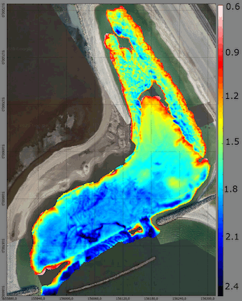
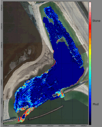
Figure 1 Left: Bottom level elevation expressed in relation to local water depth (m). Right: Bottom material type.
I. Surname1*, F.N. Another-Surname2 , Y. Next-Surname2
1 University Name, Country; 2 Organization Name, Country
* Corresponding author: mail.name@organization.org
