
T.D. Price1*, M.A. De Schipper2, J. Hopkins2, S.G.J. Aarninkhof2, B.G. Ruessink1
1 Utrecht University, {T.D.Price, B.G.Ruessink}@uu.nl
2 Delft University of Technology, {M.A.deSchipper, J.A.Hopkins, S.G.J.Aarninkhof}@tudelft.nl
Introduction
Placing sandy beaches in front of dunes to prevent future flooding under rising sea levels has been done for over three decades now along the Dutch coast. In recent years this approach has started to be used to improve weak flood defences, such as dikes and dams, in regions that are not necessarily wave-dominated. These so-called sandy retrofits replace traditional reinforcements of concrete, stones or asphalt. The Prins Hendrikzanddijk, on the landward side of the Dutch barrier island Texel, is a recent example of such a sandy retrofit. So far, our understanding of the behaviour of artificially placed sediment has primarily focussed on beaches predominantly forced by waves. Moreover, a single grain size is often assumed when studying the transport of the added sediment. This greatly hampers the prediction of coastal safety and the design of mixed-sand (i.e. various grain sizes) retrofits in mixed wave-current environments, such as around barrier islands or near river entrances.
With our recently awarded NWO-OTP project we aim to provide the quantitative knowledge and tools needed for the design and evaluation of Effective Upgrades and REtrofits for Coastal Climate Adaptation (EURECCA). More specifically, with EURECCA we aim to unravel when and where the mixed sand of a nourishment will disperse given mixed wave-current forcing conditions. Key scientific challenges are to describe (1) the evolution of the cross-shore profile of the sandy bed level in response to calm and storm periods and (2) the planform evolution and impact of different sediment sizes on this evolution.
Approach
To address above challenges, we will undertake dedicated large field campaigns at the recently completed (2019) Prins Hendrikzanddijk (Figure 1) in combination with state-of-the-art process-based model simulations. With short- and long-term field campaigns and monitoring data we will determine the threshold forcing conditions that mobilize sediment of different grainsizes. Numerical models (XBeach and Delft3D) will be applied to generalize these findings, and to propose new parameterizations in forecast and design tools.
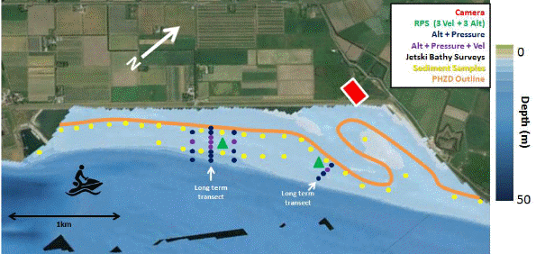
Figure 1 Schematic of planned field observations, including arrays of hydrodynamic sensors for short (monthly) and long (yearly) deployment (dark blue for pressure and depth, purple for pressure, depth, and velocity), a ripple scanner mounted on a frame with pressure and velocity sensors to capture bathymetric change (dark green). The orange line denotes the location of the seaward extent of the Prins Hendrikzanddijk.
I. Surname1*, F.N. Another-Surname2 , Y. Next-Surname2
1 University Name, Country; 2 Organization Name, Country
* Corresponding author: mail.name@organization.org
