J.L.J. Hanssen1,2*, B.C. van Prooijen1, P.M.J. Herman1,2
1 Delft University of Technology,
2 Deltares
Introduction
Worldwide, we observe creeks intersecting bare tidal flats at different latitudes and longitudes. Contrary, many tidal flats do not have such creeks. Simultaneously, there are bare flats with and without creeks in the same estuary. In this contribution, we study where and why creeks evolve on bare tidal flats.
Methods
We applied a spatial analysis and a numerical modelling approach to determine where and why creeks occur. Bare tidal flats are considered, bounded by a tidal channel and a dike or marsh edge. We sorted and selected (based on predefined criteria) areas with and without creeks based on high resolution historical aerial pictures of the Western Scheldt (WS) Estuary and Ems-Dollard (ED) Estuary. For each selected flat, creek locations were defined. We obtained multiple cross sections of each flat based from detailed LiDAR data sets of the estuaries. Each profile was fit to a mathematical formula that includes the shape parameters of the flat and related these characteristics to the occurrence of creeks.
Subsequently, flow velocities and bed shear stresses were calculated for varying flat shapes, using a 1D hydrodynamic model. The obtained results were related to the presence of creeks for different flat shapes.
Results
The tidal flats can be schematized by: a steep lower flat and mild upper flat, in between there is a curved transition zone. The analysed data set reveals that creeks occur at the transition zone between upper and lower flat. The flats with tidal creeks have a sharp transition between upper and lower slope (small transition zone).
From the 1D model follows: large flow velocities are found for mild upper slopes and locations around mean sea level.
Substituting the bed shear stress in an erosion formulation reveals that the tide-integrated erosion rate is highest at the transition zone. Hence, the highest probability for erosion and creek formation. Obtained results coincide with measurements from the field.
We conclude that creeks are found at the transition zone between the upper and lower flat on convex profiles because the flow velocities and erosion potential are highest.
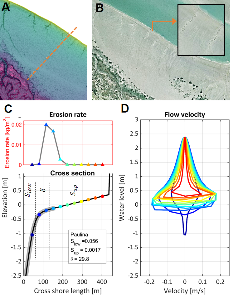
Figure 1: tidal flat Paulina (Western Scheldt). Panel A) LiDAR data with indication of transect. Panel B) Aerial picture. Panel C - low) Input numerical simulation. Cross section with indication of creek zone (grey), tidal flat parameters, observation points. Panel C - up) Erosion rate in observation points, during a tidal cycle. Panel D) flow velocities in observation points, during a tidal cycle.
I. Surname1*, F.N. Another-Surname2 , Y. Next-Surname2
1 University Name, Country; 2 Organization Name, Country
* Corresponding author: mail.name@organization.org
