L.W.M. Roest1*, G, Strypsteen1, P. Rauwoens1
1 KU Leuven, Department of Civil Engineering, Hydraulics and Geotechnics,
Introduction
Alongshore sediment transport rates are important in sediment budget studies or design of coastal structures. Underestimated transport rates give rise to severe siltation updrift from cross-shore structures and severe erosion downdrift. Overestimates may lead to over-design and thus high costs. Currently, these estimates are generally obtained from sediment transport equations, morphodynamic numerical modelling or bathymetrical changes in accumulation areas (Vandebroek et al. 2017). However, alongshore transport is difficult to estimate from regular bathymetrical surveys, since only locations with gradients in the transport will provide information via volume changes. On a straight coastline the sediment will simply pass by.
Here an alternative data-based approach is proposed, studying an access channel suffering from repeated siltation. The recreational port of Blankenberge, Belgium, is connected to open sea via a short access channel. It is only separated from the beach trough two smooth low-crested breakwaters, and two open pile structures ("staketsels"). Sediment is easily transported over the breakwaters during mid to high-tide, silting up the access channel. Bypassing around the breakwaters also takes place (Teurlincx et al. 2009).
As the access channel effectively serves as a sediment trap it can be used to study alongshore sediment transport rates. The access channel is frequently dredged and even more frequently surveyed. It is therefore suitable to make estimates of sediment transport on the time-scale of weeks to months.
Methods
A large number of multibeam bathymetric surveys are available for the years 2016-2020, covering the access channel to the recreational port of Blankenberge. Volumes are derived in three distinct sedimentation zones to each side of the channel and in front of the entrance, providing timeseries of volume change. Surveys are inspected for dredging activities in the zones and the volumes corrected as necessary.
Results
Over the course of a week (6-14 February 2020), during the passage of storm Ciara, 12*103 m3 of sand was deposited in the access channel, which is similar to the entire month (7 January to 6 February) before. A period of calmer conditions (16 December 2019 to 7 January 2020) resulted in only 2.5*103 m3. These volumes could be scaled to annual transport rates of 5.5*105, 1.5*105 and 0.4*105 m3/year respectively in North East direction. Bypassed volumes were not yet included.
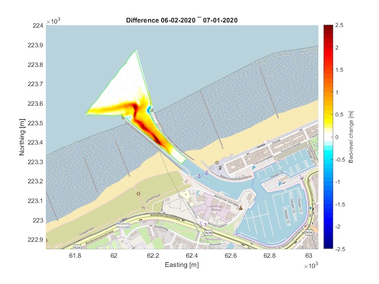
Figure: Blankenberge access channel, siltation during one month of winter conditions. Colours indicate accretion and erosion.
Bibliography
Afdeling Kust (2021). Surveys haven Blankenberge (data).
Teurlincx, R.; Van der Biest, K.; Reyns, J.; Verwaest, T.; Mostaert, F. (2009). Haven Van Blankenberge - Verminderen van de aanzanding van de havengeul en het voorplein: Eindrapport. Versie 1_1. WL Rapporten, Projectnr. Waterbouwkundig Laboratorium: Antwerpen, België
Vandebroek, E.; Dan S.; Vanlede, J.; Verwaest, T.; Mostaert, F. (2017). Sediment Budget for the Belgian Coast: Final report. Version 2.0. FHR Reports, 12_155_1. Flanders Hydraulics Research: Antwerp & Antea Group.
I. Surname1*, F.N. Another-Surname2 , Y. Next-Surname2
1 University Name, Country; 2 Organization Name, Country
* Corresponding author: mail.name@organization.org
