M. Schrijver1,2*, M. van der Vegt1, B.G. Ruessink1, M. G. Kleinhans1
1 Utrecht University
2 Rijkswaterstaat
*corresponding author:
Abstract
In the mesotidal Western Scheldt estuary in the Netherlands intertidal bars are accreting much faster than local sea level rise. To understand which processes underlie this rapid accretion a 6-month field campaign was conducted in 2019 on one fast accreting intertidal bar with the aim to identify the relevant hydraulic conditions. During this field campaign current velocities were measured at 16 different locations in the channel with Teledyne Workhorse 1200 kHz instruments and on the intertidal bar with Nortek Aquadopp Profiler 2MHz instruments. During monthly field visits the bed level was recorded with Leica GPS-1200 system (NedPos) .
The validated data shows patterns of spatial and temporal differences between different locations (Fig. 1). MP1, which is located in the western part of the channel, is flood dominant, while MP2, which is located in the east in a more shallow region in the channel, is ebb dominant. Therefore coarse sediment will most likely be transported onto the tidal bar in the western part, while the finer sediments will be deposited in the eastern part. Current speeds above the 95th percentile during the flood period at both locations are caused by storm conditions. Noticeable for MP2 is that the current speed is for a large part of the time around 60 cm/s. This effect depends on the water depth and therefore we assume that local morphology contributes to it. Further analysis will verify the agreement of measured flow velocities with idealized models intertidal flats (Friedrichs and Aubrey, 1996) and will quantify the role of wind and wave effects on the sediment transport between the channel and the intertidal bar. Furthermore, the 14 other measurement locations will be analysed.
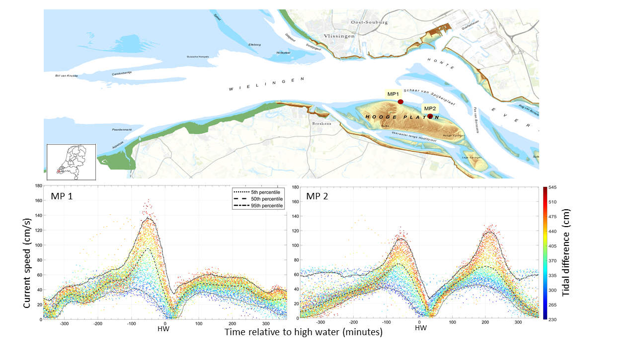
Figure 1: An overview of two locations and an example of the measured current velocity in the lowest cell at these locations during the measurement campaign in 2019.
References
Friedrichs, C.T. & Aubrey D.G. (1996). Uniform Bottom Shear Stress and Equilibrium Hypsometry of Intertidal Flats. Coast and Estuarine Studies, vol. 50, 405-429. https://doi.org/ 10.1029/CE050p0405
I. Surname1*, F.N. Another-Surname2 , Y. Next-Surname2
1 University Name, Country; 2 Organization Name, Country
* Corresponding author: mail.name@organization.org
