
H. Jongbloed1,*, B. Vermeulen1, J.Y. Zomer1, M.C. Verbeek2, A.J.F. Hoitink1
1 Hydrology and Quantitative Water Management Group, Wageningen University and Research, Wageningen, the Netherlands
2 Department of Hydraulic Engineering, Delft University of Technology, Delft, the Netherlands
*corresponding author: This email address is being protected from spambots. You need JavaScript enabled to view it.
Introduction
Tidal channel junctions play a key role in the distribution of water throughout estuarine networks. Accurate modelling of these systems, for example to predict salt intrusion, is of great importance. However, the dominant mechanisms driving salt exchange between junction branches are hard to estimate due to strongly three-dimensional flow and salinity dynamics, caused by tidal phase differences and complex geometries. To better understand the three-dimensional nature of salt transport at junctions, here we analyse two 13-hour field surveys, which were conducted in 2014 and 2015 at two tidal channel junctions in the Rhine-Meuse delta (Figure 1). Each of the junction branches was traversed once per hour, with ADCP (Acoustic Doppler Current Profiler) and CTD (Conductivity, Temperature, Depth) sensors being used to measure flow and salinity, respectively, in the branch-cross sections.
Methods
ADCP velocity data are analysed using an adjusted sigma – layered computational grid as proposed by Vermeulen et al. (2014), after which CTD salinity data are interpolated. Dominant tidal constituent amplitudes and phase differences are estimated, both between junction branches and within individual branches. Thereafter, salt transport fluxes are decomposed by separating flow and salinity in constant and varying components with respect to the vertical, temporal and lateral dimension, yielding a salt flux decomposition which allows for separation of coexisting salt transport mechanisms. In particular, fractions of tidally averaged, net longitudinal salt transport caused by correlations between lateral flow and salinity shear, are estimated.
Results
Preliminary results indicate that the tidal flow is strongly sheared across the junctions. Both junctions show tidal phase differences between the branches of up to 1,5 hours, with the southern junction showing an additional large lateral phase difference within the western branch, the Hartel Canal, of up to 2,5 hours. Differences between the junction dynamics may partly be attributed to differences in degrees of bed discordance (Fig. 1, upper right). Tidal asymmetries and associated oscillating salinity gradients are likely to influence salt transport to a larger degree than stratification, turbulence or subtidal gravitational circulation. However, due to nonlinear interactions, these phenomena are not entirely separable. Results indicate that parametrisations of dispersion coefficients and nodal point relations, currently used to model salt exchange at tidal channel junctions, may have to be improved to more accurately model the impact of complex flow patterns at channel junctions on longitudinal salt transport in one-dimensional modelling.
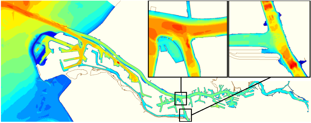
Figure 1: Locations and bathymetry of the two tidal channel junctions in the Rhine – Meuse delta. The Old/New Meuse – Rotterdam Waterway junction for the survey of September 2015 (north) and the Old Meuse – Hartel Canal junction for the survey of August 2014. Figure from Port of Rotterdam, 2014.
Vermeulen, B., M. G. Sassi, and A. J. F. Hoitink (2014), Improved flow velocity estimates from moving-boat ADCP measurements, Water Resour. Res., 50, 4186–4196, doi:10.1002/2013WR015152