J. Vroom1*, B.P. Smits1, R.J.A. van Weerdenburg1, A. Colina Alonso1,2, T. van Kessel1, J. de Vries3, E. Lofvers3
1 Deltares; 2 Delft University of Technology; 3 Rijkswaterstaat
*corresponding author:
Introduction
In 2012, the sill in the navigation channel Boontjes in the Dutch Wadden Sea was lowered to allow for bigger ships between the sluice of Kornwerderzand and the port of Harlingen (Figure 1). Nowadays, the dredging volumes are much larger than anticipated in 2012. Deltares and Rijkswaterstaat have investigated the driving factors for the high dredging volumes and estimated the (trend in) dredging volumes for the future (i.e. until 2050).
Methods
First, we analysed the large-scale morphological trends in the wider area of the Boontjes channel using bathymetric surveys. We studied dredging data and depth soundings in order to get a better impression of the sediment composition of the dredged material, the exact location of dredging and disposal and the magnitude of dredging volumes over the year. We used a numerical model (i.e. online coupling from D-Flow FM to D-Water Quality) to study tidal discharges, flow velocities, sediment fluxes and dredging volumes for historic and future scenarios. The future dredging volumes were estimated using empirical relations between tidal volumes, channel cross-section and dredging volumes (Witteveen+Bos, 2022).
Results
The western Dutch Wadden Sea experiences large sedimentation along the coast of Friesland as a response to the closure of the Zuiderzee. This sedimentation is expected to continue in the future (e.g. Grasmeijer et al. 2022). As more and more flat area will evolve from subtidal to intertidal area, the discharge through the Boontjes channel will be further reduced causing the dredging volume to increase. Model simulations show that deepening the Boontjes channel attracts flow to the channel, causing the flow velocities to increase. Nevertheless, the dredging volumes have increased after sill removal. This was likely caused by wave-driven resuspension, with higher resuspension on the flats and lower resuspension from the channel. Also, the effect of gravitational circulation intensifies at larger channel depths, transporting sediment from the disposal locations towards the freshwater source in the South.
The dredging volumes computed with the fine sediment transport model are very similar for several channel dimensions. This result is not trusted and is probably due to shortcomings in the wave model (fetch approach) and too little sediment exchange between the water column and the bed. Measurements from the field (e.g. SSC over the vertical) are needed to improve the sediment transport model.
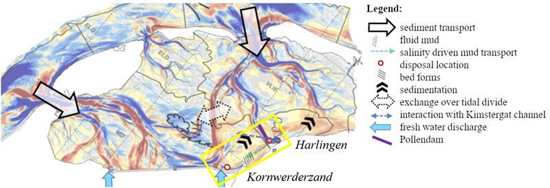
Figure 1: Sedimentation (red) and erosion (blue) map of the study area (yellow box).
References
Grasmeijer, B. et al (2022). Verkenning morfologische ontwikkeling westelijke Waddenzee. Deltares report 11208040.
Witteveen+Bos. (2022). Verkenning Bereikbaarheid Ameland 2030: Ontwerpnota baggerbezwaar en mogelijke veerroutes. Ref 126248/22-007.541
I. Surname1*, F.N. Another-Surname2 , Y. Next-Surname2
1 University Name, Country; 2 Organization Name, Country
* Corresponding author: mail.name@organization.org
