T. van Engelen*1, B. Grasmeijer2, W. Ridderinkhof1, J.C. Winterwerp3,4
1 Witteveen+Bos Raadgevende Ingenieurs; 2 Deltares; 3 i-Mud; 4TU Delft
*corresponding author:
Introduction
The primary connection between the Wadden island Ameland and the mainland is the ferry which sails between Nes and Holwerd. It follows several tidal channels within the Borndiep (Figure 1), a tidal basin within the Wadden Sea. The annual dredging volumes to maintain the fairway minimum dimensions f have increased more than tenfold since 1990, to approximately 1.9 M m3 in 2021. The increased sedimentation causes bottlenecks for the ferry service. Also, the almost continuous dredging is an environmental burden as it disturbs the seabed and locally enhances the turbidity. Currently, a study is being conducted assessing if there are sustainable alternatives for the current ferry route and deployment. To select the optimal alternative, a reliable estimate of the long-term dredging volumes is essential to compare operational effects of the current practices to the potential benefit of alternative infrastructure in the Wadden Sea.
Methods
Most of the sediment is dredged from the southern part of the fairway. To obtain an estimate of future maintenance volumes in the fairway, a relationship is derived between the tidal volume of the sub-basin fed by the channel and historical dredging volumes. Forecasts of this tidal volume are based upon different scenarios for the evolution of the tidal divide, for the observed growth rates of salt marshes, for different sea level rise scenarios, accounting for the response of the basin's hypsometry as a function of sea level rise. The latter is based on both observed sedimentation rates and sensitivity tests using an ASMITA model, which was calibrated for the Borndiep basin (Huismans, Y., et al. (2022)).
Results
It was found that the major contribution (approx. 60%) of the increase in dredging volumes in the southern part of the shipping route is to be attributed to the migration of the tidal divide in the east of the basin. The contribution by a continuous expansion of salt marshes and growth of tidal flats are estimated at 20% each. Further growth of dredging volumes to maintain the current fairway is likely to be limited by a limitation in the migration of the tidal divide. Yet, total dredging volumes may increase with up to 40% in coming decades. Depending on the efficiency of human's joint climate actions, acceleration of sea level rise may cause dredging volumes to decrease in the second half of this century.
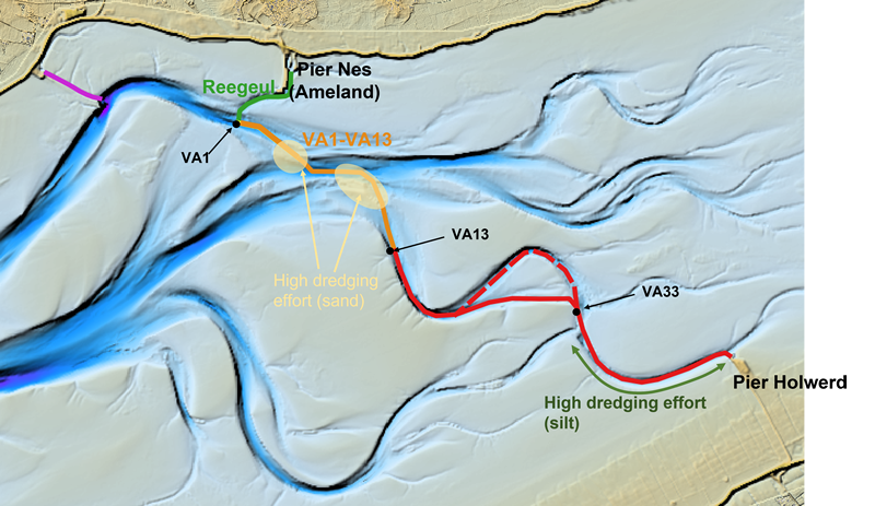
Figure 1: Coloured line shows the ferry route between Nes and Holwerd. The red (silt), yellow (sand) and green (sand and silt) lines indicate the type of sediment that is primarily dredged from that area.
References
Huismans, Y., van der Spek, A., Lodder, Q., Zijlstra, R., Elias, E., Wang, Z.B. (2022). Development of intertidal flats in the Dutch Wadden Sea in response to a rising sea level: Spatial differentiation and sensitivity to the rate of sea level rise. Ocean & Coastal Management, 216, 105969. https://doi.org/10.1016/j.ocecoaman.2021.105969
I. Surname1*, F.N. Another-Surname2 , Y. Next-Surname2
1 University Name, Country; 2 Organization Name, Country
* Corresponding author: mail.name@organization.org
