R. Schepper1, M. Moretto1*, A. Dastgheib1,2, B. Verheyen1, A. Bolle1
1 International Marine and Dredging consultant; 2 IHE Delft Institute for Water Education
*corresponding author:
Introduction
Climate change and anthropological interventions are changing the landscape of coastal zones. Coastline evolution models are key to design adaptations for coastal zone management. Several process-based models exist to predict coastline evolution with varying accuracy and computational needs. One of these is ShorelineS (Roelvink et al. 2020), used in this study, which adopts a vector-based approach and is able to deal with complicated coastline features such as spits and shoals and is relatively fast.
Study area
The present analysis focusses on the entire Belgian coastline (67 km long), along which multiple harbours are located, for which a few different coastline adaptation alternatives are being developed. The hydrodynamic conditions are characterized by; mean spring tidal range of 5 m, significant wave height of 1 m and peak period of 6 s. Waves from the southwest and the north-northeast are dominant wave conditions in longshore sediment transport along the Belgian coastline.
Model setup & calibration
To set up and calibrate the ShorelineS model, an initial coastline (LiDAR data from 2009), a wave climate (wave timeseries 30 km offshore, Westhinder) and the position of the harbours (satellite imagery), were extracted. The model is calibrated by varying several model parameters, for a 9-year period (2009-2018), such as; the active profile height, the sediment transport efficiency and the nearshore refraction depth. The calibrated model includes the nourishments during this period as well.
Application of the model in designing adaptation alternatives
The calibrated model is used to simulate a 5 year simulation using the current coastline and harbour locations and hydrodynamic conditions (named 'reference case'). After that period it is observed that the location of the shoreline hardly varies, and thus a 'stable' shoreline is obtained (Figure 1). The orientation of this 'stable' coastline is then used as baseline to build up potential adapted coastlines (named 'alternatives'), aiming at reducing the alongshore sediment transport gradient and consequently reduce erosion and need for maintenance (nourishments). The model is then used to evaluate these alternatives on the basis of required nourishment.
Conclusion
In this study it is shown how a quick and useful tool can help design and evaluate coastal adaptations, by providing the opportunity to evaluate different alternatives in reasonable time and reduce the number of viable alternatives.
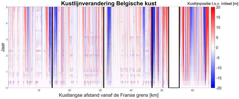
Figure 1: Cumulative evolution of the Belgian coastline, red shows sedimentation and blue erosion.
Acknowledgement
The authors want to acknowledge "Vlaamse Overheid, MOW – Afdeling Maritieme Toegang" for the financing of this study as part of the project of Kustvisie (Vlaamse Regering, 2017)."
References
Roelvink, Huisman, Elghandour, Ghonim, Reyns (2020): Efficient Modeling of Complex Sandy Coastal Evolution at Monthly to Century Time Scales, Front. Mar. Sci., vol. 7.
Vlaamse Regering 2017. Nota aan de Vlaamse Regering. Startbeslissing Complex Project Kustvisie. VR 2017 2212 DOC.1384/1."
I. Surname1*, F.N. Another-Surname2 , Y. Next-Surname2
1 University Name, Country; 2 Organization Name, Country
* Corresponding author: mail.name@organization.org
