B. De Maerschalck1*, A. Breugem2, L. Wang2, G. Kolokythas3
1 Flanders Hydraulics; 2 IMDC nv.; 3 ACTAEA Consulting Engineers L.P.
*corresponding author:
Introduction
The simulation of the long-term evolution of hydrodynamics and morphodynamics by state-of-the-art numerical modelling tools, can have important contribution to the strategic decision-making for the protection of the Belgian Coast from the climate change hazards. The SCALDIS-COAST model, developed in the present study, aspires to become a valuable tool for the assessment of potential coastal protection measures by predicting the morphological behavior of the coast driven by the coupled action of tidal currents and waves.
Methods
The SCALDIS-COAST model consists of three coupled modules, i.e. the hydrodynamic module, the wave module, and the morphology module. The hydrodynamic simulations are performed by means of TELEMAC2D module on an unstructured triangular grid, which solves the shallow water equations (Saint-Venant) on unstructured triangular meshes using the finite element method.
Wave modelling is performed by the TOMAWAC module which solves the non-stationary balance equation of the action density directional spectrum. A special module has been developed to allow for a coupled hydrodynamic and waves model with different resolution and layout in order to reduce computation times (Breugem et al.,2019).
Sediment transport and morphology simulations are conducted by means of SISYPHE module. Bed load and suspended sediment transport driven by the combined action of waves and currents are calculated by using a modified formula of Bijker (1992). Then, the bed evolution equation (Exner equation) is solved by use of the finite element formulation. The implementation of cross shore processes is currently under development.
Results
The model is validated both for long term evolution of the sea-bed after the extension of the port of Zeebrugge sea-ward 1986, but also for short term events like the erosion of the beach nourishment in 2014 at Wenduine and the siltation of the navigation channel of the Blankenberge marina during a single storm event.
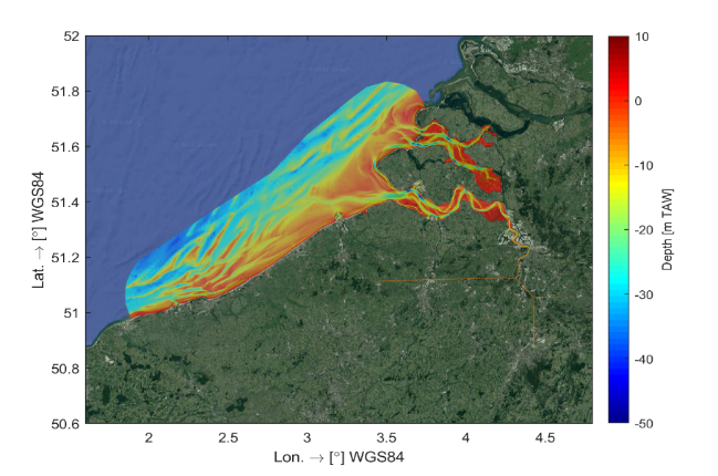
Figure 1: The computational domain and bathymetry of the SCALDIS-COAST model.
References
Breugem, W.A., Fonias, E., Wang, L., Bolle, A., Kolokythas, G & De Maerschalck, B. (2019). TEL2TOM: coupling TELEMAC2D and TOMAWAC on arbitrary meshes. In: Proceedings of the 26th TELEMAC-MASCARET User Conference 2019, 15th-17th October 2019, Toulouse–France
I. Surname1*, F.N. Another-Surname2 , Y. Next-Surname2
1 University Name, Country; 2 Organization Name, Country
* Corresponding author: mail.name@organization.org
