Ibnu Faizal1,5*, Erik M. Horstman1, Bart Vermeulen4, Katarzyna Kujawa-Roeleveld4, Roshanka Ranasinghe1,2,3, Kathelijne M. Wijnberg1
1 Water Engineering and Management, University of Twente, Enschede, 7500 AE, Netherlands; 2 IHE Delft Institute for Water Education, PO Box 3015, 2601 DA, Delft, The Netherlands; 3 Deltares, Boussinesqweg 1, 2629 HV, Delft, The Netherlands; 4 Wageningen University and Research, The Netherlands; 5 Department of Marine, Faculty of Fisheries and Marine Science, Universitas Padjadjaran, Indonesia
*Corresponding author:
Introduction
Coral reef ecosystems along tropical and temperate coastlines provide essential ecosystem services such as coastal protection, fisheries production, blue carbon capture, pollutant removal, and detoxification. Marine Protected Areas (MPAs) are commonly used as management tools to promote the sustainable use of these ecosystems. The increase of tourism in coral reef MPAs is responsible for environmental decline due to the impacts of human activities, such as increased influxes of nutrients and sediments (Kurniawan et al., 2016). Local hydrodynamics determine the transport of pollutants from the coast to the coral reefs. However, there currently is a lack of understanding on the role of local hydrodynamics on such pollution flows, impeding the development of local pollution models to directly estimate the transport and delivery of tourism related pollutants around small islands and surrounding coral reefs. We plan to investigate the local biophysical dynamics at the land-sea interface in coral reef MPAs and their impacts on the transport and dispersion of pollution related to tourism.
Methods
We combine field observations and model simulations of biophysical and pollution flows around small islands with some of the world's most diverse coral reefs in Raja Ampat, Indonesia (Figure 1).
Field data will be collected at 2-3 islands with increasing tourism development (in Dampier Strait and Misool) and during both the dry and wet seasons. The field data will be used to develop a numerical model in Delft3D to simulate pollution flows around the islands, similar to previous models for the transport of marine debris and sediments around small islands (Figure 1; Faizal et al., 2022). The model will help quantifying the impacts of various tourism intensities and activities on pollution flows around the islands and the surrounding coral reefs.
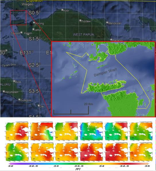
Figure 1. Study site location (top) and illustration of a biophysical model of sea water salinity [PPT] around Raja Ampat (bottom).
Expected Results
By quantifying the biophysical flows around small coral reef islands, this research aims to provide a better understanding of the pollution flows to coral reefs, allowing for the development of mitigation strategies to prevent further ecosystem degradation at tourist destinations in coral reef MPAs.
References
Faizal, I., Purba, N.P., Martasuganda, M.K., Abimanyu, A., Akbar, M.R., Sugianto, E., 2022. Physical Control on Marine Debris Spreading Around Muara Gembong, Jakarta Bay. J. Ecol. Eng., 23, 12–20. Kurniawan, F., Adrianto, L., Bengen, D.G., Prasetyo, L.B., 2016. Vulnerability assessment of small islands to tourism: The case of the Marine Tourism Park of the Gili Matra Islands, Indonesia. Glob. Ecol. Conserv., 6, 308–326.
I. Surname1*, F.N. Another-Surname2 , Y. Next-Surname2
1 University Name, Country; 2 Organization Name, Country
* Corresponding author: mail.name@organization.org
