E.B. Sipma1*, J.J. Warmink1, T.M. Duong1 and S.J.M.H. Hulscher1
1 University of Twente
*corresponding author:
Introduction
Effects of climate change, such as sea level rise and increased storminess, require solutions to provide continued safety from flooding. Living Dikes, grass-covered dikes fronted by a salt marsh foreshore, are proposed as a more climate-adaptive and resilient solution for coastal flood protection compared to conventional dike heightening. However, as salt marshes are dynamic ecosystems and thus show natural variation in space and time, these introduce more uncertainty. To realise resilient and climate-proof Living Dikes, knowledge is needed in order to understand, quantify and incorporate these spatial and temporal variations in the flood safety assessment of a Living Dike.
Approach
This research project aims to improve understanding of spatial variations and temporal development of a salt marsh as a result of natural dynamics and disturbances as well as to quantify how these influence flood safety of a Living Dike. The first part of this research project focusses on quantifying the effect of spatial salt marsh variations on the flood safety of Living Dikes. For this, a framework based on models will be developed. The setup developed by Lashley et al. (2022) will be extended to include the effect 2D salt marsh variations on wave overtopping. The second part of this research project focusses on the effect of long and short term temporal salt marsh variations and natural dynamics by developing, improving and using models (e.g. Delft3D-FM) to identify possible development pathways of salt marsh development. Influences of climate change and disturbances, such as storm events or human-induced disturbances, on these development pathways will be studied. By combining the first and second part of the project, this will give insight into both the short term and long-term flood safety of Living Dikes.
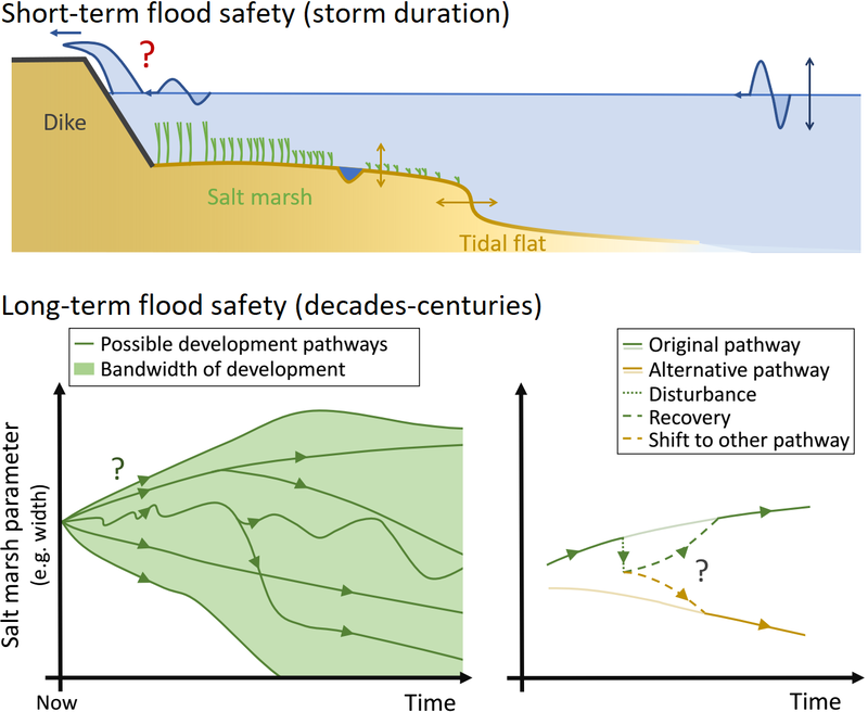
Figure 1: Graphical impression of the two main parts of the project.
Top: Schematic representation of a cross-section of a Living Dike and its effect on flood safety (question mark) based on variations in bathymetry (yellow), vegetation cover (green) and offshore hydraulic conditions (blue).
Bottom left: Schematic impression of possible natural development pathways as a result of parameter values, conditions and climate change scenarios.
Bottom right: Schematic impression of possible responses to a disturbance (e.g. storm/drought event or human intervention).
Reference
Lashley, C. H., Jonkman, S. N., van der Meer, J., Bricker, J. D., and Vuik, V. (2022). The influence of infragravity waves on the safety of coastal defences: a case study of the Dutch Wadden Sea. Natural Hazards and Earth System Sciences, 22(1), 1–22, doi: 10.5194/nhess-22-1-2022.
I. Surname1*, F.N. Another-Surname2 , Y. Next-Surname2
1 University Name, Country; 2 Organization Name, Country
* Corresponding author: mail.name@organization.org
