Juliana Tavora¹*, Marloes Vaessen¹, Elisa Fernandes2, Glauber Gonçalves3, Mhd. Suhyb Salama¹, Daphne van der Wal1,4
1 Faculty of Geo-Information Science and Earth Observation, University of Twente, Enschede, The Netherlands; 2 Laboratório de Oceanografia Costeira e Estuarina, Instituto de Oceanografia, Universidade Federal do Rio Grande (FURG), Rio Grande, Brazil; 3 Centro de Ciências Computacionais, Universidade Federal do Rio Grande (FURG), Rio Grande, Brazil; 4 NIOZ Royal Netherlands Institute for Sea Research, Dept of Estuarine and Delta Systems, P.O. 6 140, 4400 AC Yerseke, The Netherlands
*corresponding author:
Introduction
A novel algorithm is presented to detect coastal features such as turbid plumes and turbidity maximum zones (TMZs). While TMZs are zones of highly concentrated particulate matter buffering sediment exchange between land and the coastal sea, coastal plumes are a marker of major exportation of suspended sediments. Satellite Earth Observation (EO) is a valuable tool to explore the characteristics of these coastal turbid features, providing synoptic time-series. We propose to use EO data archives to investigate two contrasting turbid systems (Figure 1).
Methods
First, turbidity maps are derived from EO data for each turbid system. Secondly, a set of reference points are identified from the turbidity maps. For example, for TMZs, the algorithm runs a moving average within each turbidity map, automatically setting the reference point as the region of strongest turbidity (i.e., the core). Thirdly, the turbid coastal feature is determined by applying a measure of similarity of pixels in each satellite scene.
Results
The proposed algorithm shows adaptability to distinguish plumes and TMZs from the ambient background water. Results are shown considering the metrics of the detected turbid features (area of extension, orientation, shape, mean turbidity, core position) extracted from EO data. The observed spatial patterns and metrics of the detected coastal features are compared against state-of-the-art threshold methods. Our approach highlights the importance of re-thinking traditional methods that usually apply fixed thresholds to delimit plumes and TMZs.
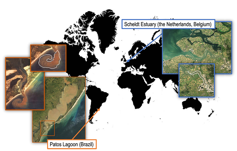
Figure 1: Location of contrasting turbid systems. White contours represent detected coastal features as observed from Landsat (United States Geological Survey – USGS) for Patos Lagoon and Sentinel-2 (European Space Agency – ESA) for the Scheldt Estuary.
I. Surname1*, F.N. Another-Surname2 , Y. Next-Surname2
1 University Name, Country; 2 Organization Name, Country
* Corresponding author: mail.name@organization.org
