R. van Bakel1*, J. T. Dijkstra2, J. de Vries1, E. Lofvers1, W. Stolte2, M. Klein Obbink1
1 Rijkswaterstaat; 2 Deltares
*corresponding author:
Introduction: cause and aims
The complex morphodynamics and dynamic nature of the Dutch Wadden Sea have been researched extensively over the last few decades. Despite being an essential part of the management and policy cycle, the related data was often scattered and hard to find. As part of the project Basismonitoring Wadden and Rijkswaterstaat research programme Management and Maintenance of the Wadden Sea (Beheer en Onderhoud Wadden), the aim of the Digital System Reporting tool (DSR) Wadden is to present up-to-date, transparent and consistent series of abiotic indicators that are easily and publicly accessible. In this way, trends and developments can quickly be detected and analysed. This contributes to a more efficient and effective execution of maintenance tasks, informs long-term policy and aids the calibration and validations of integrative models. Consequently, it is easier to identify knowledge gaps and additional monitoring needs.
Methods
The DSR Wadden is developed in consultation with stakeholders and experts. An iterative method of collecting and processing feedback was used, resulting in high-quality and usable product for stakeholders in the Wadden Sea area. Moreover, the tool makes it possible to easily update the information based on the latest monitoring data and project measurements.
Results
The DSR Wadden currently consists of more than 25 frequently used abiotic indicators and therefore enables an integrated, system-oriented monitoring of the Wadden Sea that provides a coherent insight into the functioning of the Wadden Sea system as a whole. To be prepared for current and future challenges in the area, such as morphological changes as well as the anthropogenic and climate-change-related pressures, the DSR Wadden serves as an important basis for administrators, researchers, policy makers and other stakeholders. We invite researchers to use and combine the information on the DSR and to contribute their own data to the DSR. This will enable the users of the DSR to tackle coastal engineering and science challenges in a diverse yet coherent way.
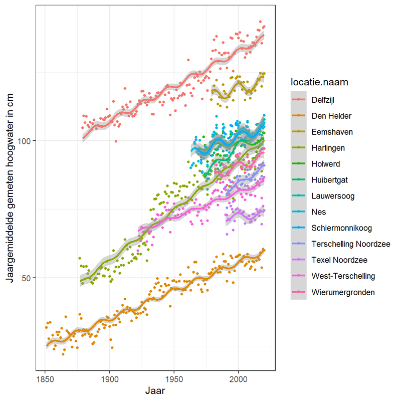
Figure 1: Example of a monitored indicator for water levels on the DSR (source: systeemrapportage.nl).
References
Stolte, W., Vroom, J., Santinelli, G., Veenstra, J., Van Oeveren, C., Van Zelst, V., Dijkstra, J. (2023). Systeemrapportage Abiotiek Wadden: Natuurmonitoring, onderdeel morfologie. https://www.systeemrapportage.nl/wadden or https://www.testsysteemrapportage.nl/wadden/ (currently only available in Dutch)
I. Surname1*, F.N. Another-Surname2 , Y. Next-Surname2
1 University Name, Country; 2 Organization Name, Country
* Corresponding author: mail.name@organization.org
