
C. Rowe1*, R. Ranasinghe2 , A. Luijendijk2 , E. Kras2, F. Calkoen2
1 IHE Delft Institute for Water Education, The Netherlands; 2 Deltares, The Netherlands
* Corresponding author: cro005@un-ihe.org ; Clenmar.Rowe@deltares.nl
Introduction
It is widely acknowledged that the coastal zone is among the world’s most rapidly developing, yet simultaneously, one of the most hazardous and exposed land-use areas. Despite their importance, these regions often lack the comprehensive data necessary for effective disaster management, including the installation of protective infrastructures. This lack of data is particularly evident in marginalized communities where resources are scarce and hampers efforts to identify and manage coastal risks, which is a crucial first step in disaster mitigation. This research aims to address this critical gap by leveraging global datasets to identify coastal risk levels on a global scale. By integrating data on hazards, exposure, and vulnerability, we can provide a more accurate picture of coastal risk levels, enabling better-informed decision-making and planning for disaster mitigation.
Objective and Methods
To achieve the objective of identifying global coastal risk levels, the study employs a multi-faceted approach. It begins with acquiring relevant datasets that capture information on hazards, exposure, and vulnerability across the globe. These datasets are then harmonized to ensure consistency and comparability. The next step involves the application of statistical classification methods and clustering algorithms to analyze the datasets and derive qualitative, standardized values for each indicator ranging between 1 and 5. The research employs a combination of both existing formulas from scientific literature and an expert "supervised" Machine Learning model to analyze the datasets and derive risk indices The global coastal risk levels at future time horizons, under the different climate projections, will be determined based on their corresponding variations in hazard magnitude. The results are formatted according to established standards like the Climate and Forecasting (CF) conventions to ensure interoperability with other climate-related datasets and models. Additionally, the research incorporates the use of SpatioTemporal Asset Catalogs (STAC) to facilitate data access and prevent the need for developing specific APIs. A web service will be hosted to allow interactive access to the risk information, including the ability to generate printable PDF summaries for a specified coastal area of interest.
Results
The anticipated result of this research is a robust, applicable coastal risk-level dataset that can be used to identify and screen particularly vulnerable shorelines worldwide. This risk level index and its constituent Hazard, Exposure, and Vulnerability datasets will provide valuable insights into the potential risks posed by natural hazards to coastal communities and infrastructure. An additional dataset integrated with future climate risk level projections will be produced and hosted on the web service. The option to toggle between both present and future climate risk level projections is expected to offer a forward-looking perspective. This will allow policymakers, planners, and community leaders in data-scarce regions to understand and prepare for the increasing impacts of climate change on coastal environments.
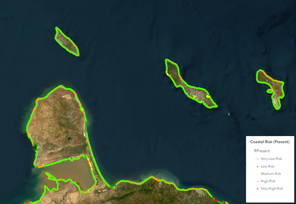
Figure 1 Sample dataset of the Netherlands Antilles, depicting an example of the expected result from this study
References
Athanasiou P, van Dongeren A, Giardino A, Vousdoukas M, Gaytan-Aguilar S, Ranasinghe R (2019) Global distribution of nearshore slopes with implications for coastal retreat. Earth Syst Sci Data 11: 1515-1529 DOI 10.5194/essd-11-1515-2019
Calkoen F, Luijendijk A, Rivero CR, Kras E, Baart F (2021) Traditional vs. machine-learning methods for forecasting sandy shoreline evolution using historic satellite-derived shorelines. Remote Sensing 13: 934
Gornitz VM, Daniels RC, White TW, Birdwell KR (1994) The development of a coastal risk assessment database: vulnerability to sea-level rise in the US Southeast. Journal of coastal research: 327-338
Koroglu A, Ranasinghe R, Jiménez JA, Dastgheib A (2019) Comparison of Coastal Vulnerability Index applications for Barcelona Province. Ocean & Coastal Management 178: 104799
Lemos G, Semedo A, Kumar R, Dobrynin M, Akpinar A, Kamranzad B, Bidlot J, Lobeto H (2023) Performance evaluation of a global CMIP6 single forcing, multi-wave model ensemble of wave climate simulations. Ocean Modelling 184: 102237
Luijendijk A, Hagenaars G, Ranasinghe R, Baart F, Donchyts G, Aarninkhof S (2018) The State of the World's Beaches. Sci Rep 8: 6641
Mclaughlin S, Cooper JAG (2010) A multi-scale coastal vulnerability index: A tool for coastal managers? Environmental Hazards 9: 233-248
Tebaldi C, Ranasinghe R, Vousdoukas M, Rasmussen D, Vega-Westhoff B, Kirezci E, Kopp RE, Sriver R, Mentaschi L (2021) Extreme sea levels at different global warming levels. Nature Climate Change 11: 746-751
