N.R. Thillaigovindarasu1,2*, S.G. Pearson1, A. Gijón Mancheño1, A.J.H.M. Reniers1 and I. Gerritsma2
1 Delft University of Technology, The Netherlands; 2 Deltares, The Netherlands
* Corresponding author: raghavi.thillaigovindarasu@deltares.nl
Introduction
Mangrove forests are important wetland ecosystems that offer a diverse array of ecosystem services, including coastal protection and carbon sequestration (Spalding, 2010). Despite their significance, global mangrove cover has declined in recent decades, prompting various restoration initiatives, most of which often fail due to a lack of system understanding of the local mangrove habitat and associated physical and biological processes (Wodehouse and Rayment, 2019). A method gaining prominence involves the use of permeable dams to restore the sediment balance along eroding coastlines, thereby facilitating the restoration of mangroves in the area (Winterwerp et al., 2020). These dams help dissipate the approaching waves and reduce current magnitudes, thus creating a low energy environment behind them, ideal for sediment deposition. However, a comprehensive understanding of the system-wide implications of utilisation of permeable dams remains largely unexplored.
Objective and Methods
The study (Thillaigovindarasu, 2023) is focused on examining the response of a coastal system to structural presence, based on currents, waves and sediment and propagule pathways, to optimise restoration strategies. The coastline of Demak in Indonesia is chosen as the system to be modelled due to the persistent erosion problem in the region and the ongoing use of permeable and impermeable structures to mitigate the problem. A nested model was set-up in Delft3D-4 to estimate the flow hydrodynamics resulting from river discharge, tide and wind forcing in the area. Wave propagation in the region was also modelled using Delft3D-4 with a standalone nested wave model. Output from the hydrodynamic models served as input for the Lagrangian particle tracking model, SedTRAILS, to compute the sediment and propagule pathways.
Results
The hydrodynamic models demonstrate a decrease in both current magnitude and wave activity behind the structures, with a greater reduction observed in the case of impermeable structures. However, the radius of influence is constrained to less than a kilometre from the structures. The sediment pathways reveal reduced sediment movement behind the structures. However, the sediment imported due to the structures are sourced from within the intertidal basin which could trigger coastline retreat in the region. Additional tests reveal that impermeable structures, with a larger length-to-opening size ratio and, positioned closer to the mangrove fringe are more effective at retaining sediment. In case of propagules, the trapping behaviour of the structures is less apparent, with dependencies on the relative location of the structure to the sources and the direction of wind. In Demak, propagules approaching from the landward side of the structures become entrapped in the region behind the structures, thereby creating a possibility for mangrove restoration. The study concludes that coastal structures enhance sediment and propagule retention, with varying efficacy depending on the type, location and length of the structure, suggesting their potential utility as a valuable tool for mangrove restoration.
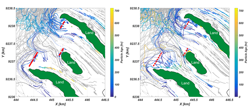
Figure 1: Sediment pathways in the presence of impermeable structures (left) and permeable dams (right). Sediment particles traversing through the area about half a kilometre behind the structures are mapped in colour according to their age (time elapsed since the particles were released), with the pathways of other sediment particles in the region in grey.
References
Spalding, M. (2010). World atlas of mangroves (1st ed.). Routeledge.
Thillaigovindarasu, R. (2023). Mangrove-Sediment Connectivity in the Presence of Structures Used to Aid Restoration: A Demak Case Study.
Winterwerp, J. C., Albers, T., Anthony, E. J., Friess, D. A., Gijón Mancheño, A., Moseley, K., Muhari, A., Naipal, S., Noordermeer, J., Oost, A., et al. (2020). Managing erosion of mangrove-mud coasts with permeable dams–lessons learned. Ecological Engineering, 158, 106078.
Wodehouse, D. C., & Rayment, M. B. (2019). Mangrove area and propagule number planting targets produce sub-optimal rehabilitation and afforestation outcomes. Estuarine, Coastal and Shelf Science, 222, 91–102.
