B. van Westen*1,2, S. de Vries2, N. Cohn3, C.O. van IJzendoorn4, G. Strypsteen5, C. Hallin6
1Deltares, Boussinesqweg 1, Delft, 2629 HV, Netherlands
2Delft University of Technology, Department of Civil Engineering and Geosciences, Stevinweg 1, Delft, 2628 CN, Netherlands
3U.S. Army Engineer Research and Development Center, Coastal and Hydraulics Laboratory, 1261 Duck Road, Duck, NC, 27949, USA
4Oregon State University, College of Earth, Ocean, and Atmospheric Sciences, 101 SW 26th St., Corvallis, OR, 97331, USA
5Hydraulics and Geotechnics, Department of Civil Engineering, Bruges Campus, KULeuven, Spoorwegstraat 12, Bruges, 8200, Belgium
6Lund University, Faculty of Engineering, Division of Water Resources Engineering, Lund, Sweden
* Corresponding author: Bart.vanWesten@Deltares.nl
Introduction
Coastal dunes offer numerous societal and ecosystem services, such as enhancing flood protection, reducing sand nuisance on adjoining infrastructure, increasing natural and recreational value, and assisting in drinking water provision. The formation and evolution of coastal dunes result from a complex interplay of biophysical processes. Dune topography influences wind patterns, leading to variations in spatial shear stress and flow separation, steering landform development. In coastal environments, vegetation plays a crucial role in stabilizing dunes by reducing shear stress. Dune vegetation species like marram grass showcase a capacity for growth under conditions of high sediment deposition, enabling the stabilization of otherwise dynamic aeolian landforms. To effectively predict the development of coastal dunes, it is essential to utilize a suitable and user-friendly tool that accurately describes these processes. Current models provide valuable insights but face limitations in practical applications due to various constraints. For a tool to be effective in real-world engineering scenarios, it must be able to simulate dune-shaping processes across scales relevant to engineering – on a scale of kilometres and decades. This involves the ability to describe realistic environmental conditions, requiring flexibility in terms of boundary conditions and realistic topographies.
Objective and Methods
In this study, we aim to provide a predictive tool for dune development based on a comprehensive description of eco-physical processes, which can be used to inform decisions on how to intervene in coastal dunes. We use the AeoLiS sediment transport model, given its open-source availability and modular setup (de Vries et al., 2023). Previous iterations of AeoLiS primarily focussed on supply-limiting effects on aeolian transport, such as soil moisture and sediment sorting (Hoonhout & Vries, 2016; Hallin et al., 2023; IJzendoorn et al., 2023). Recent enhancements to the implementation of landform-shaping process, i.e. topographic steering and vegetation, have significantly improved computational efficiency and overall model robustness, and thus its applicability for predicting dune development.
To demonstrate the model's ability to predict the evolution of diverse aeolian landforms, we simulate four distinct dune types: Barchan dunes, parabolic dunes, embryo dunes, and the formation of blowouts; the latter being highlighted in this abstract. The blowout simulation draws on the observed evolution of five excavated notches in National Park Zuid-Kennemerland (Ruessink et al., 2018). For the model setup and validation, annual topographic data provided by Rijkswaterstaat is used. The wind conditions were derived from the ERA5 hindcast, chosen for its global coverage.
Results
AeoLiS successfully simulates the early stages of blowout formation in coastal foredunes over 10 years. The model reproduces the erosion patterns observed in the notches (Figure 1a-b), which is the result of a lack of vegetation cover and increased airflow through the blowouts (Figure 1d). In the simulation, the centre of each blowout undergoes significant erosion, reaching the presumed groundwater table, with the majority of erosion occurring along the erosional walls (Figure 1b). The model also captures the sediment deposition patterns landward of the notches. However, it predicts these deposits to be more concentrated and closer to the blowout sites than what is observed in actual measurements. A volumetric analysis reveals that the model estimates the erosion volume at ~127,000 m3, being a slight overestimation of 14% compared to the measured volume (Figure 1e). On the other hand, the model underestimates the amount of sediment transported from the beach to the backdune through the blowouts by about 60%.
Our study results show the ability of AeoLiS to predict several aspects of real-world blowout formation, in addition to barchan, parabolic and embryo dune development. This demonstrates its potential applicability to simulate real-world coastal dune development at engineering-relevant spatial and temporal scales.
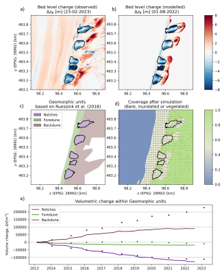
Figure 1. Overview of the development of five excavated notches at the National Park Zuid-Kennemerland. The observed (a) and modelled (b) bed level changes are compared in the upper panels. The sand coverage, water level, and vegetation cover at the end of the simulation are shown in d), together with arrows indicating wind flow, averaged over the last year. The volumetric changes within the different geomorphic units (c), based on Ruessink et al. (2018), are shown in the bottom panel (e).
References
Hallin, C., van IJzendoorn, C., Homberger, J. M., & de Vries, S. (2023). Simulating surface soil moisture on sandy beaches. Coastal Engineering, 185, 104376.
Hoonhout, B. M., & Vries, S. D. (2016). A process‐based model for aeolian sediment transport and spatiotemporal varying sediment availability. Journal of Geophysical Research: Earth Surface, 121(8), 1555-1575.
van IJzendoorn, C. O., Hallin, C., Reniers, A. J. H. M., & de Vries, S. (2023). Modeling Multi‐Fraction Coastal Aeolian Sediment Transport With Horizontal and Vertical Grain‐Size Variability. Journal of Geophysical Research: Earth Surface, 128(7), e2023JF007155
Ruessink, B. G., Arens, S. M., Kuipers, M., & Donker, J. J. A. (2018). Coastal dune dynamics in response to excavated foredune notches. Aeolian Research, 31, 3-17.
de Vries, S., Hallin, C., van IJzendoorn, C., van Westen, B., Cohn, N., Strypsteen, G., Skaden, J., Agrawal, N., & Garcia Alvarez, M. (2023). AeoLiS (Version 3.0.0.rc1) [Computer software]. Retrieved from https://github.com/openearth/aeolis-python
