
E. Brand1*, A.-L. Montreuil1, M. Chen1
1VUB,
Introduction
The intertidal zone is a very dynamic area subject to waves, tide, and wind and topographic changes can be large over a short period of time. For macro-tidal coasts (tidal range >4 m), it remains unclear what specific hydrodynamic conditions lead to topographic changes. This is mainly due to a scarcity of reliable field data of sediment transport and beach topography. This study investigates the intertidal beach morphodynamics based on extensive field measurements resulting in a conceptual model of hydrodynamic forcing and topographic response. Two study sites are examined along the Belgian coast: a multi-barred beach (Groenendijk) and a beach with a featureless intertidal zone (Mariakerke).
Methods and results
During six fortnight measuring campaigns, three at each study site, the hydrodynamics and sediment transport were continuously measured at the low water line. Topographic profiles were measured every day at low tide. It is found that the intertidal beach grows when waves are small (wave steepness < 0.010), whereas it erodes when waves are large (> 0.025). For medium wave steepness (0.010-0.025) this is opposite, which is attributed to a sudden rise in sediment supply. This rise is likely related to waves breaking over the sandbanks in front of the coast and at beaches southwest of the study sites. The relationship between wave steepness and intertidal beach volume is heavily distorted by spring-neap variations in tidal current direction though. Strong alongshore currents transport sediment away from the beach during spring tide which enhances erosion. In contrast, currents are cross-shore and wave-dominated during neap tide. The impact of variations in tidal current direction on the intertidal beach topography is in the same order of magnitude as wave impact. The effect of variations in sediment supply is subordinate to the impact of waves and tide. The main mode of sediment transport in the intertidal zone is in suspension. Currents reach a maximum at approximately 1.5 m above the bed resulting in a peak in sediment transport. The mean sediment transport is onshore by tidal currents during calm conditions, while it is offshore by undertow during energetic wave conditions (wave height > 0.6 m or wave steepness > 0.025). Oscillatory transport is always onshore because of wave asymmetry but is subordinate to the mean transport.
Conclusions
It is concluded from this study that waves are not necessarily the dominant forcing factor on macro-tidal beaches. Tidal currents can be equally important and can contribute significantly to the transport of sediment. Besides waves and tidal currents, variations in sediment supply influence the changes in the intertidal beach topography. A conceptual model is provided to illustrate the relationship between hydrodynamic forcing and topographic response.
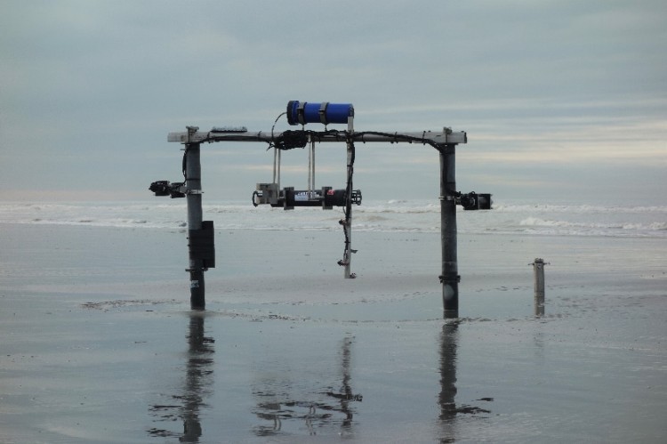
Figure 1 Measuring frame on the intertidal beach with equipment to measure wave height, flow velocity, suspended sediment concentrations, and grain size.
I. Surname1*, F.N. Another-Surname2 , Y. Next-Surname2
1 University Name, Country; 2 Organization Name, Country
* Corresponding author: mail.name@organization.org
