Rikke van der Grinten1, Anne Ton2, Jan-Willem Mol3, Rinse Wilmink3
1 Nortek BV,
3 Rijkswaterstaat,
Introduction
The present Houtribdijk reinforcement project foresees in an innovative measure to guarantee safety against flooding. For the first time ever, a sandy nourishment is applied to ensure large-scale stability of a levee in a non-tidal, inland lake environment. To gain detailed insight in the key hydrodynamic and morphological processes, a dedicated monitoring program is carried out at the foreshores of the Houtribdijk and sandy beaches of the Marker Wadden. This program is developed and executed by Rijkswaterstaat in collaboration with TU Delft and supported by Nortek products and services.
Start of long-term monitoring campaign
Rijkswaterstaat deployed six permanent measurement stations in the vicinity of the levee. Additionally, six smaller stations are temporarily deployed and moved around between areas of interest. Rijkswaterstaat deployed all measurement stations in February 2019 and is responsible for preventive and corrective maintenance. The project will run continuously for at least two years, while measuring during several heavy storms. A real-time data set from each station is produced.
Instruments and data
The extensive data set contains measurements of five types of sensors. In total 22 sensors are allocated at the measurement stations: 6 ADVs, 2 HR ADCPs, 6 regular ADCPs, 6 step gauges, 2 water quality probes and 6 altimeters. These sensors produce a total of 300 MB raw data per day!
The challenging job to send the data and post process the data is executed by Nortek (data transfer), and HKV and Tauw (post-processing and data management). This wealth of information is further analyzed by Anne Ton, PhD candidate at TU Delft.
First results
From initial analysis of ADV results, interesting differences between hydrodynamics on both sides of the Houtribdijk become clear. On the Markermeer side, water level and wave height are positively correlated for southeasterly and southwesterly winds. On the IJsselmeer side, these are positively correlated for northwesterly and northeasterly winds. Both imply that wind driven set-up coincides with increasing wave height. For southerly winds, a wind-driven set down is found on the IJsselmeer side.
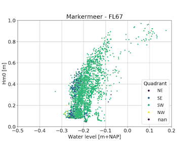
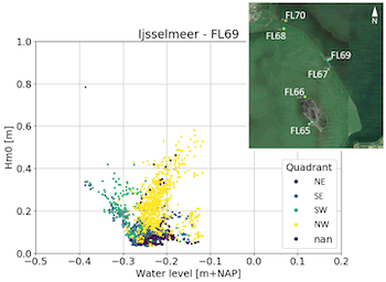
Figure 1 Correlation water level and wave height from ADV measurements
This monitoring campaign will facilitate evidence-based insights into the hydro- and morphodynamics of non-tidal, sandy environments, that will help ensure safety of the Houtribdijk and similar nature-based solutions.
I. Surname1*, F.N. Another-Surname2 , Y. Next-Surname2
1 University Name, Country; 2 Organization Name, Country
* Corresponding author: mail.name@organization.org
