
A.M. Ton1*, V. Vuik1,2, R.J.A. Wilmink3, S.G.J. Aarninkhof1
1 TU Delft,
2 HKV,
3 Rijkswaterstaat,
Introduction
Hydrodynamic and morphological processes at low-energy or sheltered beaches can be significantly different compared to open, high-energy coasts. Ton et al. (2020) set up a conceptual model for morphological development of low-energy, sandy beaches in the cross-shore direction based on data from newly-constructed lake beaches. Next to this initial cross-shore profile readjustment, the data revealed additional sediment losses driven by gradients in the alongshore sediment transport rate. The goal of this research is to find out how longshore transports affect the sediment volume balance and how these transports are driven by hydrodynamic conditions typically found at low-energy coasts.
Results and Conclusion
Two densely monitored study sites at the Houtribdijk and the Marker Wadden, both located in the large shallow lake Markermeer, are used to study longshore transport in low-energy, non-tidal environments. In general both locations suffer from net erosion at the shoreline. At the Marker Wadden, sediment is deposited below 0.7 m below annual average water level over almost the whole length of the beach, except for coastline outcrop at -250 m (x-direction) (Fig. 1A). This beach experiences a net sediment loss, indicating longshore transport. Similar erosion around the shoreline is seen at the Houtribdijk, but the sedimentation below 0.7 m below annual water level is less uniformly distributed (Fig. 1B). Deposits occur mostly near the dams, also indicating longshore transport and possibly more intricate sediment transport patterns. By studying bathymetric surveys and corresponding hydrodynamic measurements, we deduced sediment transport pathways and their governing hydrodynamic conditions, showing the importance of wind and thus wave direction and external factors like dams.
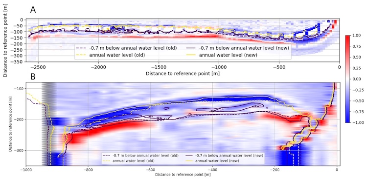
Figure 1: Sedimentation/erosion at Zuidstrand Marker Wadden (FL65), Oct 2019-Jul 2020 (A) and Houtribdijk (FL67), May 2019-Apr 2020 (B).
Acknowledgements
This research is part of the LakeSIDE project, which is funded by Rijkswaterstaat.
References
Ton, Vuik, & Aarninkhof, (2020). Sandy beaches in low-energy, non-tidal environments: Linking morphological development to hydrodynamic forcing. Geomorphology.
I. Surname1*, F.N. Another-Surname2 , Y. Next-Surname2
1 University Name, Country; 2 Organization Name, Country
* Corresponding author: mail.name@organization.org
