L. Beyaard1*, E.W. Nota1 , M.G. Kleinhans1
1 Utrecht University, Department of Physical Geography
* Corresponding author: l.beyaard@students.uu.nl
Introduction
Estuaries have complex morphodynamical patterns, which are mainly explored through the analysis of intertidal bars. Reliable visual identification of channels and their network has remained challenging, as ebb and flood channels evade one another and traverse bars. Even in well-studied estuaries such as the Western Scheldt, long-term channel network evolution has remained unexplored due to this. Here we use a novel channel network detection tool on historic elevation models of the Western Scheldt (Sonke et al., 2022).
Objective and Methods
In this research, we aim to characterize the channel pattern and its change in the historic Western Scheldt. A selection of historical hydrographic maps of the Western Scheldt and its mouth were digitized from 1804 until 1960. After converting time-specific reference levels to NAP, digital elevation models were obtained. The seven digital elevation models were used as input for the channel detection tool. This channel recognition tool computes local minima and steepest decent paths and then assigns ‘importance’ to paths based on a sand volume measure. A network of channels is obtained for every time step.
Results
From the turn of the nineteenth century, the main channel bends of the Western Scheldt have expanded towards the banks (Figure 1). The main channel sinuosity increased from 1.2 in 1804 to 1.4 in 1960. Smaller channels are generally located in similar positions throughout time. Fluctuations in their position and length occurred in response to complex bar development and land reclamations which disconnected secondary basins from the estuary. These positions were not sensitive to bathymetry resolutions below 200 m.
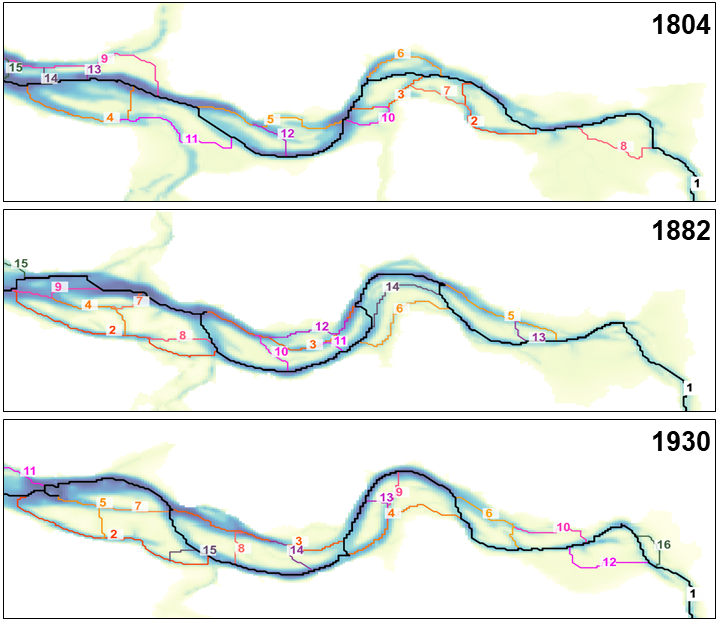
Figure 1: Channel networks derived for the historic Western Scheldt, from top to bottom for 1804, 1882 and 1930. Channel numbers indicate their importance, where the black line (1) is the main channel.
References
Sonke, W., Kleinhans, M. G., Speckmann, B., van Dijk, W. M., & Hiatt, M. (2022). Alluvial connectivity in multi-channel networks in rivers and estuaries. Earth Surface Processes and Landforms, 47(2), 477–490. https://doi.org/10.1002/esp.5261
