H. Castro Lara1*, B. Roest1,2, A. Dastgheib1,3, W.A. Breugem1, B. Verheyen1, A. Bolle1
1 IMDC, Belgium; 2 KU Leuven, Belgium; 3 IHE-Delft, The Netherlands
* Corresponding author: hilario.castro.lara@imdc.be
Introduction
Low-lying densely-populated areas are vulnerable to the effects of climate change and require long-term strategies for coastal adaptation. The ‘Kustvisie’ project started in 2017 with the goal of achieving a broadly supported, technically-sound and executable ‘Coastal Vision’ for the Belgian Coast, conducting an integrated design study supported by a co-creation process.
During this co-creation process, different long-term coastal protection strategies were assessed. The preferred strategy involves seaward shifts of the coastal profile by means of sand nourishments. These nourishments are likely to interact with the system of tidal gullies and shoreface-connected ridges which is present in front of the Belgian Coast. The MOZES project (Dujardin et al, 2023), currently aims to improve understanding of the interactions between the shoreline and the nearshore seabed on decadal time-scales. These long-term interactions are relevant for future management of the Belgian coast. Understanding these interactions is also important on shorter timescales (i.e. storms).
Objective and Methods
This study aims to gain insight into the effect of the interaction of large seaward profile shifts and tidal gullies on sediment transport and sediment losses during storms. Firstly, the system formed by tidal gullies and shoreface-connected ridges in the Belgian coast is characterized, and the spatial overlap of the seaward nourishment strategy within Kustvisie is determined. Subsequently, a numerical study is performed with XBeach (Roelvink et al, 2008). Here, the response of a cross-shore profile at Raversijde to a T10 storm was assessed in quasi-2D mode. The profile includes the Kleine Rede tidal gully, with bed levels between -6 and -9.5 m TAW and the Stroombank located on its offshore side, with a crest elevation of -3 m TAW.
The model was validated for hydrodynamics by comparing tidal currents to the largely-validated Scaldis-Coast model (Consortium Hoogtij(d) (IMDC, ORG, Arcadis), 2023) . For sediment transport, model validation was not possible and the worst-case scenario in terms of seaward cross-shore sediment transport was sought by cancelling out the wave shape effects contributing to onshore transport (i.e. asymmetry and skewness).
Beside the benchmark scenario, the numerical model has been used to analyse the effect of the presence of a tidal gully and the effect of different nourishment scenarios.
Results
Model results suggest that the presence of a tidal gully leads to slightly increased net offshore sediment transport outside the active zone during storms. Thereafter, sediments are more likely to be transported in the longshore direction due to slightly enhanced tidal currents in the gully. Relative differences shown in this modelling exercise are however limited.
Large seaward profile shifts through nourishments also seem to lead to a slight increase in the offshore-directed net transport during storm conditions. These transports, although already small in absolute numbers, vary from almost none to a small relative increase depending on the nourishment scenario. In addition, model results show that these types of nourishments do not directly impact the longshore transport in the tidal gully, therefore not increasing potential alongshore losses in the seaward strategy.
First estimates on storm-induced sediment transport for seaward nourishments along the Belgian coast in presence of tidal gullies are presented. Although only limited differences are found, it is still highlighted that taking into account the presence of tidal gullies is relevant in maintenance assessments during further research (including a calibrated cross-shore sediment transport model) for the implementation of the seaward strategy.
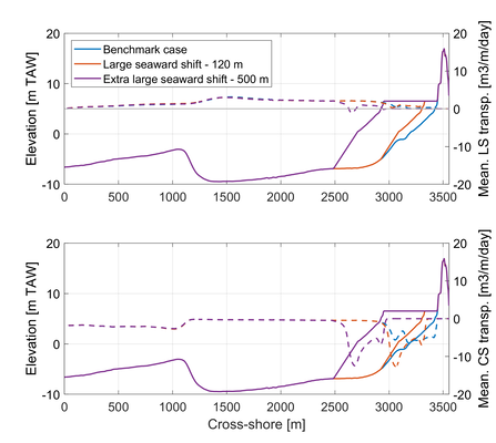
Comparison of benchmark XBeach run (i.e. Original profile, in blue) with two nourishment scenarios: Large 120 m seaward shift (in red) and extra-large 500 m seaward shift (in purple). (Top figure) Estimated mean long-shore transport. (Bottom figure) Estimated mean cross-shore transport.
References
Dujardin, A., Houthuys, R., Nnafie, A., Röbke, B., van der Werf, J., de Swart, H.E., Biernaux, V., De Maerschalck, B., Dan, S., Verwaest, T, (2023). MOZES - Research on the Morphological Interaction between the Sea bottom and the Belgian Coastline. Working year 1. WL Rapporten, Flanders Hydraulics Research, Antwerp, Belgium, 155
Roelvink, D., Reniers, A., van Dongeren, A., van Thiel de Vries, J., McCall, R., Lescinski, J., (2008). Modelling storm impacts on beaches, dunes and barrier islands. Coastal Engineering, Vol 56, 11-12, 1133–1152
Consortium Hoogtij(d) (IMDC, ORG, Arcadis)., (2023). Kustvisie - Referentiesituatie hydromorfologie.
